CUTTER BUSINESS TECHNOLOGY JOURNAL VOL. 34, NO. 11

Cutter Consortium Senior Consultant Helen Pukszta explores the use of drones for sustainability. From the critical application of precision agriculture to whimsical light shows, drones not only provide new functionality, they do so with a low carbon footprint. In precision agriculture, we see again that the data collection capability of drones coupled with sophisticated optimization algorithms can help farmers use natural resources more efficiently. In an unusual application that most would not think of, Pukszta goes on to illuminate the unintended environmental consequences of fireworks and the benefits of using drones for light shows.
Drones count citrus trees in Florida1 and penguin chicks in Antarctica,2 detect invasive species in Illinois3 and shore erosion in coastal Australia,4 and can plant trees and help restore degraded habitats. In all our civilian endeavors, public and commercial, it seems no idea for a drone application is off the table, and we learn of new ones that help people and our planet daily. Their relatively small environmental footprint, maneuverability, task versatility, accessibility, and ease of use make drones great tools in the drive for sustainability.
Drones, also referred to as unmanned aerial vehicles (UAVs), are aircraft with no pilot to carry aboard, no cockpit, and not much need for special materials, instruments, or safety-critical systems normally required of manned aircraft. Because drones are unmanned, their size can fit the purpose without the need to accommodate humans onboard. Unlike today’s airplanes and helicopters, most drones run just fine on batteries. By nature of their design, they are inherently energy-efficient.
The two areas selected and highlighted in this article, precision agriculture and drone light shows, are already here and thriving. Although quite disparate, both illustrate how adaptable and accommodating drone technologies can be to applications where saving the environment and creating economic value are not inversely related.
How Energy-Efficient Are Drones?
The future positive impact of drones on the environment has been predicted mostly in two areas related to advanced air mobility: package delivery and passenger air taxis. The latter is still a few years out. The technology has not solidified enough — not only of the vehicles themselves but of the infrastructure needed to fly them safely and efficiently — to closely evaluate its effect on sustainable development, though the benefits will likely be immense. Package delivery on a commercial scale is not quite here yet either, but it is much closer, and studies conducted in this area can serve as a good baseline to approximate the energy efficiency and environmental impact of commercial drones in general.
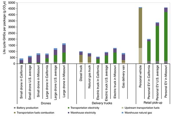
Most drones use lithium-polymer (Li-Po) or lithium-ion (Li-ion) batteries. One study, funded by the US Department of Energy and the RAND Corporation, analyzed the lifecycle greenhouse gas (GHG) emissions per one-pound package delivered by a battery-powered drone as compared with current systems of delivery. The GHG estimates included battery production, transportation electricity, upstream transportation fuels, transportation fuels combustion, warehouse electricity, and warehouse natural gas. The study showed that the total energy used by a small drone is far lower than with any other ground-based transportation.5
Battery-powered drones typically last in the air for 20 to 30 minutes and need to be recharged frequently; their relative advantage in low carbon footprint is closely tied to how green the energy is that charges them in the first place. As US and worldwide electricity industries transition to generating fewer GHG emissions, carbon intensity of electric power varies from region to region (see Figure 1). For example, according to the aforementioned study, if a small drone was charged in California, the lifecycle reduction in GHG emissions was an impressive 54%; if it was charged in Missouri, which uses mostly coal to produce electricity, it would be a still impressive but much lower 23%.
As is the case with other lithium battery-powered products from personal electronics to electric road vehicles, drones’ environmental footprint increases when their impact on natural resources and end-of-life disposal is considered. The demand for raw materials used in lithium battery production for all types of applications is expected to increase annually by 30%, resulting in significantly higher consumption of lithium, graphite, cobalt, nickel, and manganese and in associated resource-intensive mining.6 Globally, it is estimated that only 5% of all lithium batteries are recycled, as mining is still the cheaper option and recycling requires energy-intensive processes to recover the materials in a usable form.7 For drones and their batteries to firmly enter the circular economy, they need to be recycled, and the extraction of the reusable materials will best be accomplished through robotics and automation.8
In the context of deliveries, drones are in the lead for energy-efficient delivery of packages and goods. This conclusion is based on the combination of smaller electric drones charged by low-carbon electric power, small packages to deliver, and expected improvements in battery life and efficiency that will accommodate heavier loads in the future.
But comparisons with ground transportation cover only part of drones’ lower energy consumption advantage. When a task can be performed only from the air, the primary competition is non-drone, manned aircraft. Such aircraft, having to accommodate the pilot in its size and design but all else being equal, are less efficient. Longer-endurance UAVs that use gasoline or hybrid gasoline-electric propulsion systems to extend the range and flight time are available.
Hybrid designs, in particular, hold a lot of potential by combining a practical level of endurance with payload capacity, using increasingly more efficient power systems. For example, some models use the gasoline engine not to power the aircraft but to generate electricity in flight that is used to power the UAV in a high-efficiency, gas-to-electrical power conversion. Their lithium battery also acts as backup to safely land the drone in case of engine failure. By taking advantage of gasoline’s higher energy intensity and electric power, this design can be more efficient than powering with a battery alone on longer, heavier flights.
Wherever drones are used — in mapping, inspections, research, public safety, or spraying of crops — similar efficiencies apply. Drones can be used to enable sustainability while at the same time leaving a relatively small environmental footprint themselves.
Growing More with Less: Drones in Precision Agriculture
Precision agriculture is a set of farming management practices that produces higher yields through more efficient use of critical resources such as land and water, as well as lowered consumption of fossil fuels, fertilizers, and pesticides. Precision agriculture benefits crops, soils, groundwater, and the entire crop cycle and is now considered a cornerstone of sustainable agriculture.
The technology that made precision agriculture possible enabled farmers to locate an exact position in the field, and then gather data and apply crop management strategies specific to that location. The core technology is GPS (Global Positioning System, owned and operated by the US government) and, more broadly, GNSS (Global Navigation Satellite System, comprised of satellite navigation systems owned and managed by individual countries). GPS enabled the auto-guided systems used on the ground with tractors (pioneered by John Deere in 2001), sprayers, and other equipment to help avoid mistakes, such as missing patches of land or covering the same area twice. Adoption of satellite imaging, GIS (geographic information systems), Internet of Things (IoT) devices, and drones soon followed.
What Farm Drones Do
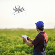
Drones help carry out many farm management activities: crop scouting, weed detection, soil assessment, plant counting, harvest planning, drainage and irrigation assessments, and anything else that an aerial view can inform.9
Aerial imagery for agricultural use has long been accomplished with satellites and manned aircraft. However, satellite images lack the spatial (i.e., image quality) and temporal (i.e., image frequency) resolution that a regularly scheduled airplane outfitted with a sophisticated camera could provide. Compared to these traditional methods, drones are a low-cost option that can provide superior resolution of images without producing gas emissions, or significantly lower emissions if a gas or hybrid UAV is used. It is a safer option that does not put a pilot at risk when flying over difficult terrain, particularly when the flight needs to be conducted close to the ground. Provided there is a remote unmanned aircraft systems (UAS) pilot on hand, the drone can be deployed at a moment’s notice, weather conditions permitting, with none of the overhead normally associated with manned aircraft. And, unlike satellite images, drones capture data at low altitudes and are not affected by cloud cover.
Drones used in agriculture can carry RGB (visible light), multispectral, thermal, LiDAR (light detection and ranging), and hyperspectral sensors, each with a different purpose for capturing aerial data. Multispectral analysis, for example, looks at how strongly plants absorb or reflect different wavelengths of sunlight, and drones help identify which crops are flourishing and which need help.10 Aerial images of crops taken using red, green, blue, red edge, near-infrared, and thermal image bands are used to create normalized difference vegetation index (NDVI) maps, which are graphical indicators based on a mathematical interpretation of color and near-infrared data. NDVI maps can show whether the target area contains live vegetation, point to differences in crop performance (one area may have too little fertilizer and another too much), and help assess plant vigor and health. Any variability may point to issues with irrigation, pest invasions, soil or seed quality, or disease.11
Drone-collected images also produce orthomosaic, thermal, or digital surface maps that can be used for crop planning or to identify areas of drought or flooding. Advanced agronomy solutions combine drone, satellite, weather, and field operations data with artificial intelligence for early pest and disease detection and provide insights that help farmers make optimized decisions about how and when to intervene for optimal yields.
Data from drone missions can promote better timing and precision of variable-rate seeding and chemical applications. Drones themselves can be outfitted to spray fertilizers, herbicides, fungicides, and pesticides. They follow the terrain precisely to maintain a constant altitude above the crops and are uploaded with variable-rate maps to help adjust the volume of chemicals sprayed based on the location derived through GPS positioning. Although the efficiencies aren’t always there when spraying large areas — drones have limited payload capacity, the weight of which more quickly depletes batteries — they can apply seeds and chemicals with precision that only UAV maneuverability can support, which in turn results in less drift and environmental impact.
By using drones to help reduce the cost of water, fertilizers, and pesticides, farmers are getting a better return on their investment, while also contributing to environmental stewardship.
How Farm Drones Perform Their Jobs
A wide array of agriculture drone platforms is now available. Some are highly specialized solutions tightly integrated with post-processing and analytical software; some cover a part of the workflow, such as high-end sensors that can be mounted on a variety of drones; and some are simply prosumer-grade UAVs that get the job done with an off-the-shelf drone equipped with a camera.
That last category is making UAVs a viable option to small farmers globally, allowing them to spot issues sooner than with the human eye. However, the large monoculture systems we are accustomed to in the US are easier to analyze and diagnose using aerial data than the smaller, diversified crops grown together that are more prevalent in developing countries.12
A readily available drone addresses both the spatial and the temporal resolution of captured data. The state of the crop can be assessed, and any issues addressed, at precisely the right time, and at meaningful and adjustable intervals corresponding to each crop’s growth pattern that, although generally predictable and consistent, will vary from season to season. For example, there may be a small window of opportunity after a storm to assess the extent of a flood or other damage in a part of the field that may be difficult to access by foot.
An automated drone mission that canvasses an area in a consistent and efficient flight pattern can be planned quickly with a few clicks. The flights can be repeated, or adjusted as needed in the field for area size, flight altitude, and other parameters. Drone missions can produce and present results quickly and lead to faster decision making.
The long-range connectivity and endurance needed to gain efficiencies when covering a large area is no longer reserved for fixed-wing drones, which generally last longer and can cover more ground. Smaller, multirotor UAVs tend to be the most energy-efficient per mile traveled, but they only last for about 30 minutes before needing a battery change. Their payload capacity is also limited. For example, they do not easily accommodate heavy tanks of chemicals for large-area spraying. However, there are more drones available now that offer the benefits of a multirotor — hovering in place, making quick turns, needing only a small space for takeoff and landing — and possess the endurance of a fixed-wing UAV.
Limitations & New Directions
Despite the benefit of a low carbon footprint, drones are not the answer in every case. Satellite images are still required for big-picture aerial analyses, and surveys and applications covering very large areas are still best accomplished with a manned aircraft. But the boundaries of these limitations continue to be challenged by accelerating innovation in drone technologies.
Internet connectivity and bandwidth limitations in rural areas can hamper the speed at which farmers get their insights. The simplest case of retrieving images from a drone’s secure digital (SD) card after it lands may meet the needs of a smaller farm but is no longer sufficient with larger operations, particularly when drones are integrated into the farm’s IoT ecosystem. Data can be uploaded to the cloud so processing can start in flight, but networking bottlenecks and reliability issues can slow the process. This is changing as more processing is taking place aboard the drone itself and alternative and proprietary networking solutions can now be deployed in the field. Once 5G networking becomes broadly available, it will provide the capacity to take what today’s drones offer to a new level.
Complete automation of drone operations is also within reach. Drone-in-a-box capabilities of autonomous flights that consider weather conditions, automatically recharge drone batteries, initiate continuous flights, and house the drone between missions are becoming available. They are subject to regulatory restrictions (e.g., for BVLOS [beyond visual line of sight] missions), but relevant Federal Aviation Administration (FAA) waivers can be obtained for safe operations in rural areas in the US.
The availability, ease of use, and just-in-time precision of a drone are hard to match. Drones will continue to be a cost-effective and energy-efficient enabler of precision agriculture and many other sectors and industries, and trusted tools for sustainability.
Beautiful & Fun, Fireworks Sparkle at a Cost
On New Year’s Eve 2010, the city of Beebe, Arkansas, witnessed the death of 4,000 to 5,000 red-winged blackbirds after a series of loud detonations of professional-grade fireworks were set off near the birds’ winter roost. Blackbirds have poor eyesight and don’t fly at night. Roused from their roost and disoriented, they crashed into houses, cars, chimneys, and each other. Necropsy reports showed trauma primarily to the chest, consistent with crashing, rather than falling.1 Studies of birds erupting into panicked flights en masse as a result of noise from fireworks have been reported with waterfowl and other birds as well; in some cases, birds abandon their young in their nests.2 In the summer, birds are generally dispersed and not as affected as during winter displays when they roost together.
Aside from traumatizing wildlife, pets, and many humans, fireworks, mostly the consumer type, present a significant risk of fires. The origin of the El Dorado fire in California in September 2020 is one terrifying example. The fire, which burned more than 22,000 acres, required the expenditure of nearly US $40 million in suppression costs, and took the life of a firefighter, was started by a pyrotechnic device at a gender-reveal party at a park in Yucaipa, California.3 Today, in areas that experience extreme dry conditions, which are increasing in number and duration, all fireworks, even prescheduled professional ones, are being banned or cancelled.
Although pollutants released in pyrotechnic explosions, in aggregate, are not significant compared to the volume produced by burning fossil fuels, they do contribute to air pollution and pose health risks.4 For example:
-
Fireworks produce a surge in fine particulates, microscopic particles that are 2.5 microns in diameter and can travel deep into the lungs. Particulate matter is among the top global environmental health concerns.5 On 4 July 2021, one Indiana city reached an hourly average of 154 micrograms per cubic meter; the US Environmental Protection Agency (EPA) threshold for unhealthy air is 35.6 The EPA allows states to discount exceptional events, such as community fireworks, in reporting their air quality statistics.
-
Perchlorate salts that provide oxygen for the combustion (although cleaner fireworks operators, including Disney, claim to no longer use them) dissolve in water and can contaminate groundwater, rivers, and lakes. Ingested perchlorate ions can interfere with iodide uptake into the thyroid gland.
-
Sulfur dioxide, which gives fireworks the distinctive smell of burnt matches, can be toxic at high concentrations.
-
Metals such as barium, copper, lead, titanium, and aluminum that give the blasts their color and sparkling effect can also have negative effects on the health of humans and animals and damage cells and lungs.
It is important to point out that most of the pollution from fireworks, and ER visits due to related injuries, is caused by the volume of backyard amateur displays. Professional shows at large community events are run by firework technicians who have years of experience and safety training. These shows pose much less immediate risk because there are fewer of them, and they are launched far enough into the sky to dissipate before reaching spectators. Still, pollutants can be blown around for miles in atmospheric wind currents and affect the wildlife and the environment in the sky and below.7
1Opar, Alisa. “Illegal Fireworks Likely Cause of Massive Arkansas Blackbird Deaths.” Audubon, 4 January 2011.
2Fimrite, Peter. “Gualala Residents Explode over Fireworks Ban.” SFGate, 20 June 2008.
3Gabbert, Bill. “Gender Reveal Party That Started El Dorado Fire Leads to Charges for Involuntary Manslaughter.” Wildfire Today, 21 July 2021.
4Mousavi, Amirhosein, et al. “Impact of 4th of July Fireworks on Spatiotemporal PM2.5 Concentrations in California Based on the PurpleAir Sensor Network: Implications for Policy and Environmental Justice.” International Journal of Environmental Research and Public Health, Vol. 18, No. 11, 27 May 2021.
5“Festival Fireworks Celebrations’ Health Impact on Vulnerable People — Study.” University of Birmingham, 21 January 2020.
6Bowman, Sarah. “Scrub Hub: Smoke from Fireworks Is Laced with Toxins, Particles That Can Send You to ER.” Indianapolis Star, 13 July 2021.
7“Are Fireworks Bad for Air Quality?” IQAir, 13 August 2021.
Less Boom, More Wow: Reusable, No Pollution Drone Light Shows
Fireworks are a staple of centuries-old traditions and celebrations worldwide. Yet the environmental impact and the risk of fires from pyrotechnic displays are significant (see sidebar above). A budding industry based on the innovation of using choreographed swarms of small drones carrying lights, or other special effects devices, has been putting on shows for public viewing in place of, and alongside, fireworks.
Drone light shows have the potential to disrupt how the live events industry and corporate departments responsible for event planning deliver the optimal package of entertainment, special effects, advertising, and messaging. The public is likely most familiar with light shows performed by Intel during the Superbowl 2017 half-time performance in Houston, Texas, and recently at the Tokyo 2020 Olympics. But there are a number of other providers in the US and globally delivering spectacular drone shows of all sizes.
Drone shows use swarms of small drones, from a handful to a thousand or more, each equipped with an LED light acting as a pixel in a choreographed set of images in the sky. Think of them as points in a low-resolution Georges Seurat painting or elements in a photomosaic that blanket the sky — the mind fills in the gaps and mixes the colors — but in a three-dimensional, immersive viewing experience. UK-based Celestial, a self-described “drone art company that fuses technology with soul” illustrated the technology’s capabilities by creating a video in conjunction with Greenpeace.13 This production used 300 illuminated drones to create images of iconic animals to send a message to world leaders attending the 2021 G7 summit in Cornwall, England.
Flown at a safe distance from audiences and over one meter apart from each other, drones used in light shows are equipped with technology (including real-time kinematic positioning (RTK)–enhanced GPS for outdoor performances) that allows them to follow positioning precise enough not to collide with each other and ensure they can quickly enact dynamic 3D animations by forming eye-pleasing shapes and lines. The drones tend to be very small in size. With no payload to carry anything other than a small LED light that changes colors based on preprogrammed choreography and a battery that limits how long they can fly, the drones can be tiny, but the size and design also reflect the tradeoffs in ensuring that the UAVs can withstand some wind gusts without collisions or flyaway incidents.
The show itself, or the dance, is designed either in proprietary software that is part of an integrated system, or in standard 3D applications familiar to animation designers, in which case the animation is then validated and imported into the software that runs the show. The swarm performance is automated and centrally controlled; the drones in the swarm generally do not communicate with each other and do not perform any autonomous actions. The UAVs are managed as a group, but the operator has visibility into each drone’s status and performance, and the overall setup employs varying degrees of hardware, software, and networking redundancies and controls.
Intel’s drones and software are proprietary, and the majority of other providers, such as Pennsylvania-based Verge Aero and Michigan-based Firefly Drone Shows, have used their own custom systems. They pair the software they developed either with UAVs they also developed in-house or with modified, off-the-shelf consumer drones.
A Latvia-based company, SPH Engineering, which develops and markets commercially available drone show software, has pioneered a different approach. Its software can be paired with a number of drone models available on the market, creating an opportunity for new entrants to deliver drone shows without the need to build the drones or develop the software to run them, or even to integrate them.
SPH Engineering has been on a mission to lower the barriers to entry for drone show providers, whether established companies or new industry participants, by building flight path precision and layers of safety into its software, partnering with UAV manufacturers that make compatible drones, and spearheading an international community of drone show enthusiasts. Other independent makers of drone show software are beginning to appear on the market as well.
In any drone show endeavor, the learning curve tends to be steep, depending on skills and capabilities already present; safety and operational risk management are always front of mind. But a well thought out drone show enterprise can acquire the drones and the software and, in the US, for example, apply for the FAA 14 CFR § 107.35 waiver, assuming flight operations will be performed under the Part 107 rules, which is almost always the case.14 This allows a pilot in command (PIC) to operate more than one drone at a time. The waiver is a key prerequisite to legally performing drone shows in the US and, like all FAA waivers to Part 107 rules, requires documentation of possible operational risks while flying, and the methods used to mitigate them.
Drone light shows can easily run the gamut from large, sophisticated displays that can be integrated into a broader entertainment or advertising experience, to small celebrations among friends and family. International mega-events will likely continue to be dominated by large players with deep pockets like Intel or China-based EHang. But the technology itself should no longer be the barrier, and it will be the creative and operational capabilities of drone show providers that will define winners in this space. The size and rate of growth of the drone show market will be tied to safety records, technical reliability, and overall cost. Maybe that next gender-reveal party will use a small drone show instead of fireworks, and someone’s family reunion entertainment will feature a DJ who lights up the sky with a small fleet of drones.
Drone shows can’t exactly match what traditional pyrotechnics produce, but they can complement (and even carry) fireworks, replace them with a different, environmentally cleaner experience, and easily surpass the level of customization, targeted messaging, and creative expression that pyrotechnics can offer. Although it is a niche industry, the application of drones in live events and entertainment demonstrates the versatility of drone technologies in creating new opportunities as well as new paths to sustainability. Watch for more such applications to appear and dazzle.
References
1“Technology Helps Growers Count Citrus Trees.” Citrus Industry Magazine, 5 June 2020.
2“Multiple UAV Approach Reduces Time to Survey Penguin Nests and Chicks.” UgCS, 25 March 2021.
3“Tracking Down Invasive Species with Drones.” University of Illinois at Urbana-Champaign, 30 July 2020.
4Pucino, Nicolas, et. al. “Citizen Science for Monitoring Seasonal-Scale Beach Erosion and Behaviour with Aerial Drones.” Scientific Reports, Vol. 11, No. 3,935, 16 February 2021.
5Stolaroff, Joshuah K., et al. “Energy Use and Life Cycle Greenhouse Gas Emissions of Drones for Commercial Package Delivery.” Nature Communications, Vol. 9, No. 409, 13 February 2018.
6da Silva Lima, Lígia, et al. “Life Cycle Assessment of Lithium-Ion Batteries and Vanadium Redox Flow Batteries-Based Renewable Energy Storage Systems.” Sustainable Energy Technologies and Assessments, Vol. 46, August 2021.
7Porzio, Jason, and Corinne D. Scown. “Life-Cycle Assessment Considerations for Batteries and Battery Materials.” Advanced Energy Materials, Vol. 11, No. 33, 14 July 2021.
8Woollacott, Emma. “Electric Cars: What Will Happen to All the Dead Batteries?” BBC News, 27 April 2021.
9Gerard, Sylvester (ed.). “E-agriculture in Action: Drones for Agriculture.” Food and Agriculture Organization (FAO) of the United Nations (UN) and International Telecommunication Union (ITU), 2018.
10Rattigan, Kathryn. “Drones in Agriculture May Keep the Farm Going.” The JD Supra Knowledge Center, 8 October 2021.
11VanderLeest, Zach. “Choosing the Right Imagery: Best Management Practices for Color, NIR, and NDVI Imagery.” Integrated Crop Management News, Iowa State University Extension and Outreach, 17 May 2016.
12Popescu, Alexandra. “Making Drones Work for Small Farmers.” GreenBiz, 18 July 2019.
13“300 Drones. One Message. Act Now.” Greenpeace, 11 June 2021.
14“Part 107 Waiver.” US Federal Aviation Administration (FAA), accessed November 2021.